Mapping the Trails of Maderas Volcano National Park
Ometepe Island is formed by two cone shaped volcanoes emerging from Lake Nicaragua and it represents one of the sites with the highest potential for tourism development in the country. Although the island is still mainly characterized by agricultural activities and a rural life style, tourism is increasingly driving development, as it is becoming a major source of income. The entire island has been declared as a Biosphere Reserve by the UNESCO in 2010. This new status will hopefully help to improve land use planning and natural resources management, and promote sustainable tourism.

The two volcanoes on Ometepe–Concepción and Maderas–are protected areas, representing part of the core zone of the Biosphere Reserve; however, funding for conservation remains scarce, and management plans or government staff are widely absent. Maderas Volcano has recently been declared a National Park. It protects one of the most important primary cloud forests of the country, as it remains widely intact and harbors endemic tree species, such as Ardisia ometepensis. The volcano offers many opportunities for tourism activities, such as hiking or exploring archeological sites. In the absence of a protected area administration, these activities are organized by local communities or hotels. The management of visitation impacts is becoming essential, as more and more tourists are visiting these unique and fragile sites.
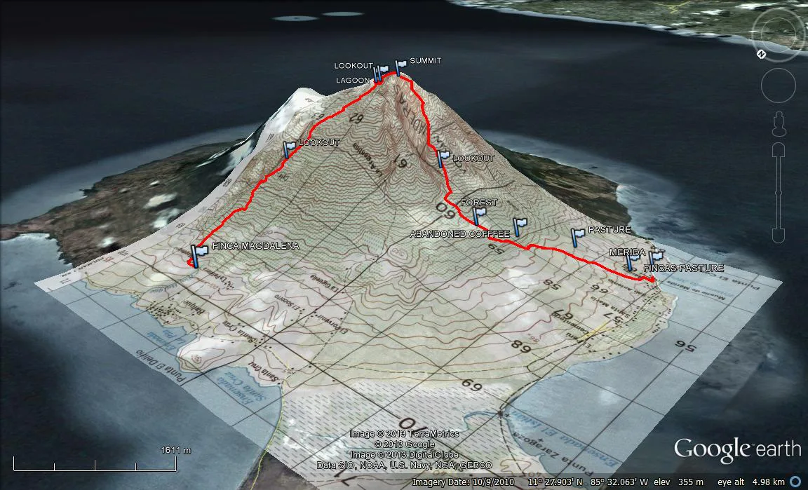
One of the most important bases for protected area management is mapping and zoning to determine attractions, site accessibility, and possible negative impacts from visitation. In 2012, SFS started mapping the trails within Maderas Volcano National Park. This semester we covered a major part of the trail system, during a 9-hour expedition that took us from nearly sea level up to 1395 m (4577 feet), over the cloud-swept summit of the volcano and back down the mountain to the shores of Lake Nicaragua.
The goal of the project is to map the extent, condition, attractions, and facilities of the entire trail system. We used several hand-held GPS receivers and two survey grade GPS units, which were provided by Lyndon State College, Vermont, to obtain an accurate trail map. Students have the opportunity to gather relevant field data by using GPS technology and to produce professional maps for conservation and recreation management by using Geographical Information System (GIS) software. Our goal is to make this information available to a broad range of potential users, such as tourist guides, hotels, and local authorities as a tool for sustainable tourism planning and management.

Related Posts

Restoration on a Cinder Cone: A Syntropic Story

Camila Rojas: Alumni Spotlight⭐
